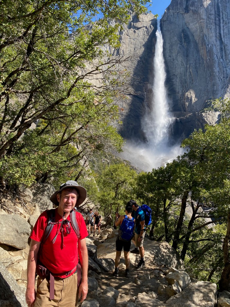
YOSEMITE NATIONAL PARK, CA – Yesterday I hiked to the rim of Yosemite Valley to look down on one of the tallest waterfalls in North America and then on to Yosemite Point for a sweeping view of Half Dome and the valley floor below. It was one of the most demanding and rewarding hikes I’ve ever tackled.
Upper Yosemite Falls plunges 1,430 feet to the rocks below, where the water cascades to the top of Lower Yosemite Falls, to tumble another 320 feet. From the top of the upper falls to the base of the lower falls, the water drops a total of 2,425 feet. The trail to the top of Upper Falls rises 2,700 feet from the trailhead, and Yosemite Point lies a few hundred feet higher, for a total elevation gain of 3,000 feet. Roundtrip, the hike was 8.8 miles.
After climbing steep switchbacks and stone stairs much of the first part of the hike, I was rewarded with a view from the bottom of the upper falls, with Half Dome in the distance. The spray was enough to wet the screen of my iPhone.
From there the trail follows more switchbacks to the rim of the valley and then down a few hundred feet to a viewing rock at the top of the upper falls. Leaning over a sturdy steel guard rail, I was able to snap a few photos of the falls roaring over the precipice. Thanks to the iPhone wide-angle lens feature, I was able to capture not only the falls but also the valley below.
And from there it was on to Yosemite Point. The trail there is about a mile, crossing Yosemite Creek only about a hundred feet upstream from the falls. The view from there rivals that of Glacier Point on the opposite rim, with Half Dome dominating the east end of the valley.
The hike down was easier on my heart and lungs but more challenging for my brain and balance. With all those stone steps, I had to choose my footing carefully. Once I slipped on a sand-covered step and fell back on my bottom, and at least three other times I had to catch myself. My total time on the trail, including breaks, was about 6 hours.
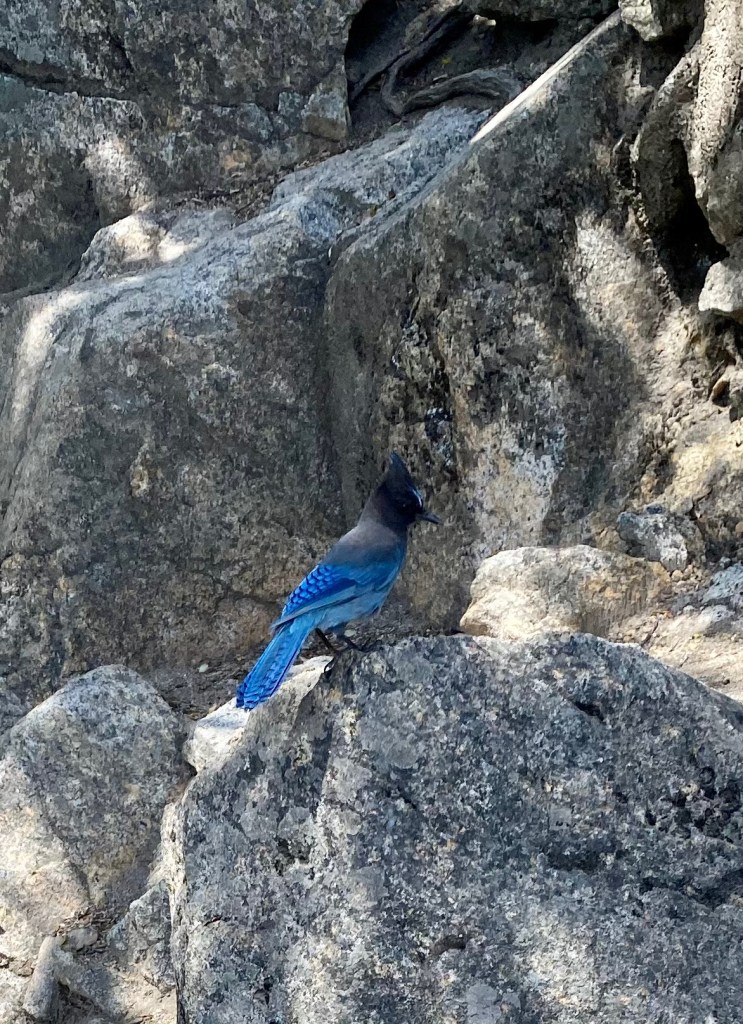
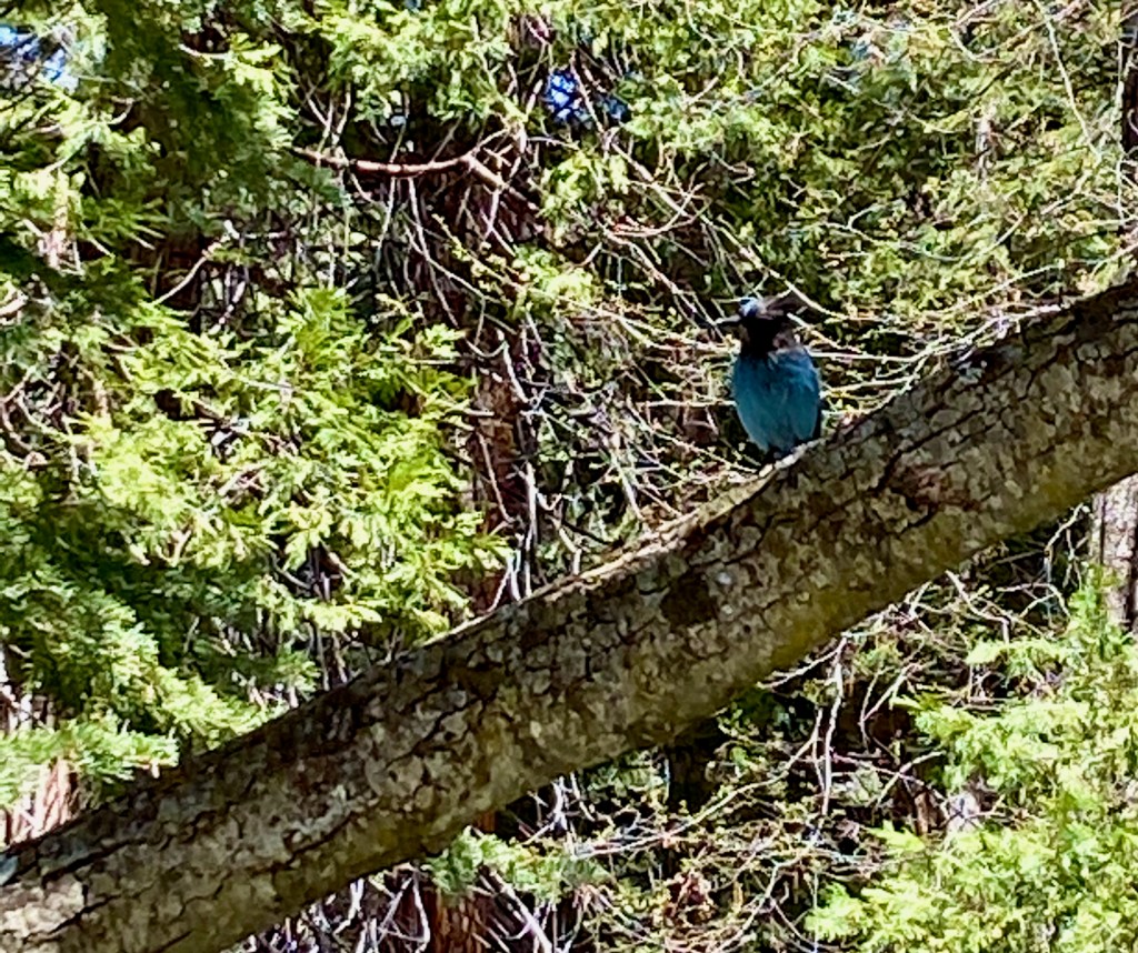
Here are three more photos from the trip down: 1) A look back at Upper Yosemite Falls; 2) Half Dome; 3) A friendly steller’s jay, the same kind of bird that was waiting for a cracker at Muir Rock in Kings Canyon.
***
A few general observations about Yosemite N.P.: It’s an incredibly scenic place, and if you’ve ever thought of visiting, don’t put it off too long. Early May is a great time of year to visit the park. You miss the summer vacation hordes, which means you can enter the park anytime without making a reservation, which will be required this year starting on May 21. Temperatures are warm, in the 70s and low 80s during our visit, but not too hot.
Another benefit of an early spring visit is that the snow melt is still feeding the waterfalls and rivers. When people think of Yosemite, they tend to picture El Capitan and Half Dome, and rightly so, but what brings the park alive is the sound of crashing water. All the major waterfalls—Bridalveil, Yosemite, Vernal, and Nevada—are flowing generously during our time here. That flow can greatly diminish or dry up entirely later in the summer with the last of the snow melt.
Yosemite would be worth visiting even in the drier season, but it would seem to me a diminished experience—like visiting a magnificent concert hall but without the music.
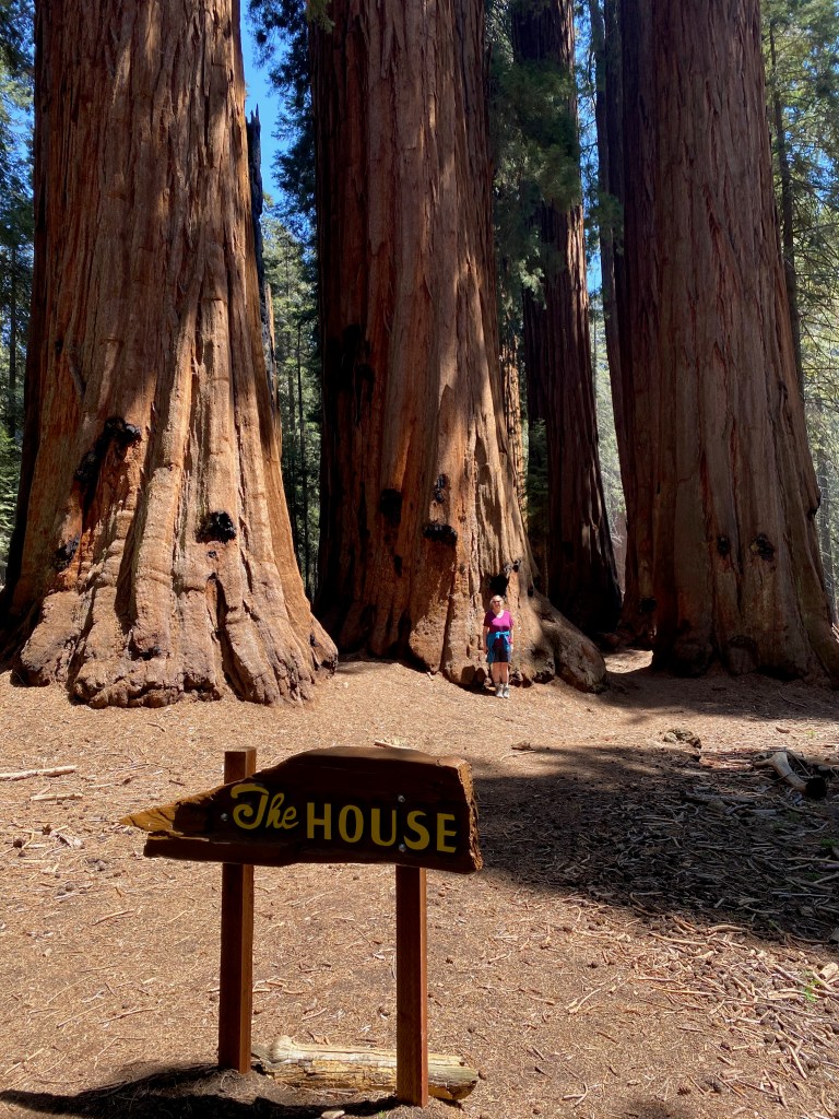
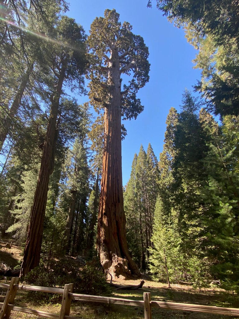
LEMON COVE, CA – On Saturday we spent the day in Sequoia National Park, walking the pine-scented trails and staring up at the biggest trees we’ve ever seen.
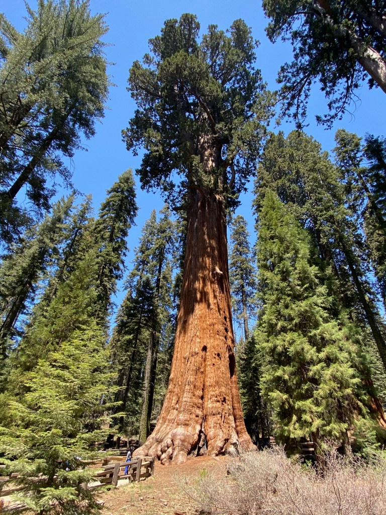
Sequoias grow only in a limited area of California, along mountainsides at about 6,000 feet above sea level. The centerpiece of Sequoia N.P. is the General Sherman Tree, considered the biggest in the world in terms of the volume of wood it contains. From there we walked two miles along the Congress Trail, past groves of sequoias, one called the House and another the Senate.
The General Sherman Tree.
It’s impossible to capture the immensity of these trees with a camera. They can be 250 feet tall with trunks 100 feet in diameter. We enjoyed walking among the trees, ducking into the crevices often created by past forest fires, and looking up the copper-colored trunks to the green pine branches far above the forest floor. It’s a sight we’ll never forget.
***
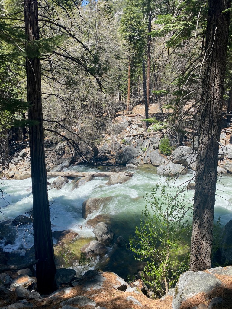
On Monday, we drove a bit further north to the adjacent Kings Canyon National Park, which has its own stand of sequoias as well as the spectacular canyon carved into the mountainside by ice-age glaciers. The main attraction among the sequoias is the General Grant Tree, which is actually a bit wider in circumference than the General Sherman Tree but not as voluminous in wood. Nearby is the Fallen Monarch, a giant sequoia that fell centuries ago but continues to provide a shelter in its hollowed trunk that was used by explorers and even army cavalry.
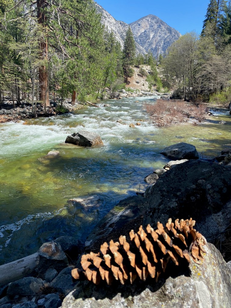
Further up the canyon, we enjoyed the views of the South Fork of the Kings River, with stops at Grizzly Falls and Roaring River Falls. At the end of the 30-mile Kings Canyon Scenic Byway, we enjoyed a restful time along the river on Muir Rock, where the naturalist John Muir would give talks on preserving the surrounding wilderness. Today the rock serves as a swimming hole. I was tempted to jump in, but the spring run-off water was too cold even for me!
Here are a few photos from Kings Canyon N.P.: 1) The General Grant Tree; 2) Roaring River Falls; 3) along the South Fork of the Kings River; 4) Looking up river–with a huge pine cone I placed on a rock for perspective and color; 5) This bird waited patiently on a limb above Muir Rock, and was rewarded when a couple nearby left a cracker out for the bird to snatch; 6) On Muir Rock looking up river. Right behind me was a popular jumping off point for swimmers.
One book I’ve finished on this RV trip is Alexander Solzhenitsyn’s novel Cancer Ward. A Christian brother recommended it three decades ago, telling me that it was so vivid in its portrayal of patients in a Soviet hospital in the 1950s that he felt like he had cancer himself.
Solzhenitsyn is one of my favorite authors. In his fiction and non-fiction, he portrays ordinary human characters living and dying in an inhuman system. His writings remind me what’s important in life and to never take our blessings and freedoms for granted. It never fails to put my own problems in perspective when I recall the life of a prisoner, or zek, trying to survive in a Soviet prison camp.
Back in my 20s, I read the first two (of three) volumes of Solzhenitsyn’s The Gulag Archipelago, one of the most important literary works of the 20th century. In his detailed account of the Soviet prison camp system and the suffering it afflicted on millions, the Russian dissident exposed to the world the evil at the heart of communism.
More recently, along with Cancer Ward, I’ve read another of his novels, In the First Circle, and an abridged version of The Gulag Archipelago that covers all three volumes and was produced with the author’s input and approval before his death in 2008. Since “the first circle” is a reference to Dante, I’ll briefly review the three works starting from the deepest circle in the man-made hell Solzhenitsyn describes.
In the abridged version of The Gulag Archipelago, Solzhenitsyn chronicles the creation of the vast prison system that began soon after the communist revolution in Russia in 1917. He tells the history of the system as well as hundreds of individual stories of the people raked into its maw.
Among the passages that affected me most were those about what it means to be arrested and to undergo interrogation and torture. He writes that even medieval torturers didn’t “understand how narrow are the limits within which a human being can preserve his personality intact.” After arrest you must put your past firmly behind you and tell yourself that the life you knew is over.
Many of the most heartbreaking stories involved women and children in the prison camps: a 10-year-old girl from a Christian family who defied her captors; a 14-year-old boy who told the truth about life in the camps to the visiting Soviet author Maxim Gorky, and was later shot for his honesty; and the 18-year-old girl forced to stand in freezing water for two hours.
Liquidating the kulaks, or successful farmers, as a class meant that for every communist agent the farmers killed in self-defense, “hundreds of the most industrious, enterprising, and level-headed peasants, those who should keep the Russian nation on an even keel, were eliminated.” At the Great Break of 1929, whole nations were exiled.
Solzhenitsyn blames ideology for the mass killings of the Gulag. He notes that Shakespeare’s evil-doers stopped at a dozen corpses because they had no ideology. He tells the story of the hundreds of thousands of Soviet soldiers who were prisoners of war, only to be sent directly to the Gulag when they were repatriated. He rightly asks, “A Motherland that betrays its soldiers—is that really a Motherland?”
In the chapter, “Ascent,” he writes about spiritual growth in the camps and learning not to judge others. As he wrestled with good and evil in his own heart, Solzhenitsyn writes,
And it was only when I lay there on rotting prison straw that I sensed within myself the first stirrings of good. Gradually it was disclosed to me that the line separating good and evil passes not through states, nor between classes, nor between political parties either—but right through every human heart—and through all human hearts.
Of the Christian believers he encountered in the camps, he says they endured “without wavering, and without spiritual collapse. They were all honest, free from anger, hard-working, quick to help others, devoted to Christ.”
***
In the First Circle is set in a special corner of the Soviet prison system, the sharashka, a research prison for engineers and scientists who work on projects for the Soviet state. It is still within the inferno of the Gulag, but in a less brutal part, hence the “first circle.”
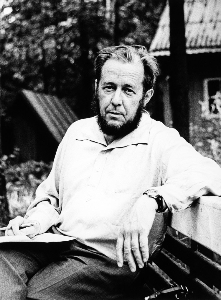
Solzhenitsyn tried to get a self-censored version of this work published in the Soviet Union in the mid-1960s, but the brief thaw that allowed the publication of A Day in the Life of Ivan Denisovich had closed by then. The photo below is Solzhenitsyn in 1967, when he was in his late 40s and still a member of the writer’s union. The version I read is the uncensored original.
Life in the research prison was not as bad as the Gulag camps, but it was bad enough. Prisoners could see their wives for only a half hour a year, their mail was censored, and their family members on the outside were subject to discrimination.
My favorite characters were Innokenty Volodin, the privileged diplomat who came to understand the horrors of the system, and Spiridon, the simple peasant who ached for his teen-age daughter who was prisoner in a lumber camp. Nerzhin was the character most like Solzhenitsyn.
The profile of Stalin was chilling but also kind of funny. In late night hours, he would enjoy listening to his old speeches. He was a prisoner in his own way to his paranoia and self-absorption.
Among the most tragic of the prisoners was the 1945-46 “stream” of former POWs who were lured back with pamphlets that said, “The Motherland forgives. The Motherland calls.” While America was greeting its POWs with the GI bill, “sturdy Russian prisoners of war [were] exchanging a German stalag for their fatherland’s Gulag.”
The translation was beautiful, with memorable lines and passages throughout. Among my favorites:
If we live in a state of constant fear, can we remain human?
Only sick people alone with their illness (and not in a hospital!) could live an untroubled life in the Soviet Union.
They came back [from the front] cleansed by the proximity of death.
Must love for your native land extend to any and every government it may have? Must you go on abetting it in destroying its own people?
Where should you start reforming the world? With other people? Or with yourself?
Two prisoners debating whether mankind has progressed: “Well, we aren’t burning one another at the stake anymore.” “Why bother with firewood when you’ve got gas chambers?”
Yes, [Volodin] had enjoyed so many blessings! But the most precious of blessings had never been his: the freedom to say what you think, the freedom to associate openly with your intellectual equals.
The Gulag is a country in which a grown man working twelve hours a day cannot earn enough to feed himself.
[For a discussion of the book and Solzhenitsyn’s broader significance, I highly recommend this Econtalk podcast with host Russ Roberts and Russian literature professor Kevin McKenna of the University of Vermont. On another episode, Roberts discusses Solzhenitsyn’s work with historian Stephen Kotkin of Princeton University.]
***
Cancer Ward is a story based on Solzhenitsyn’s real-life experience of nearly dying from the disease when he was living in exile in central Asia in 1953-54. By then he had escaped the hell of the Gulag to the relative “freedom” of life as an ordinary Soviet citizen.
After reading the book, I can confirm my friend’s assessment: Some of the most memorable passages are when the author describes the chronic pain of the patients in the ward. One leans his head over the edge of the bed all day, unable to do anything but long for the next round of pain relievers. Another struggles to turn his head because of the size of the tumor growing on his neck.
The main character in the book, Oleg, lives a simple life in the cancer ward, but he can be grateful that he is no longer in the Gulag:
there were other joys, sufficient in themselves, which he had not forgotten how to value: the right to move about without waiting for an order; the right to be alone; the right to gaze at stars that were not blinded by prison-camp searchlights; the right to put the light out at night and sleep in the dark; the right to put letters in a letterbox; the right to rest on Sunday; the right to bathe in the river. Yes, there were many, many more rights like these. And among them was the right to talk to women. His recovery was giving him back all these countless, wonderful rights.
Another theme of Cancer Ward is contentment. As the author writes: “It is not our level of prosperity that makes for happiness but the kinship of heart to heart and the way we look at the world. Both attitudes lie within our power, so that a man is happy so long as he chooses to be happy, and no one can stop him.”
In passing Solzhenitsyn reflects on the Soviet health system compared to a private system where people pay at least something toward their care. When one character exults that it is one of the greatest achievements of the Soviet system that health care is a free service, another responds:
Is this in fact such a great achievement? What does ‘free’ mean? The doctors don’t work for nothing, you know. It only means that they’re paid out of the national budget and the budget is supported by patients. It isn’t free treatment, it’s depersonalized treatment. If a patient kept the money that pays for his treatments, he would have turned the ten roubles he has to spend at the doctor’s over and over in his hands. He could go to the doctor five times over if he really needed to.
Later the character reflects, “Well, out there, out there in the camps, we used to argue that there was a lot of good in private enterprise. It makes life easier, you see. You can always get everything. You know where to find things.”
And finally, even though the book takes place outside the Gulag, the labor camp system casts a shadow over those who suffered under it:
The icy world which had shaped Oleg’s soul had no room for “unpremeditated kindness.” He had simply forgotten that such a thing existed.
The Uzbeks and the Kara-Kalpaks had no difficulty in recognizing their own people in the clinic, nor did those who had once lived in the shadow of barbed wire.
A man dies from a tumor, so how can a country survive with growths like labor camps and exiles?
I hope these passages and my reflections will spur more people to read Solzhenitsyn’s work. We cannot fully understand the world we live in, or our own human hearts, without at least a basic knowledge of the horrors that took place on a grand scale in the 20th century, and those taking place on a smaller scale today.
LEMON COVE, CA – We drove 185 miles north yesterday to this area of citrus groves after a week in the Los Angeles area.
One of the highlights of our time in LA was a ferry ride on Wednesday to Catalina Island, which lies about 29 miles southwest from the Port of Long Beach. We spent a full day on the island with our dear sister-in-law Bernadette, who lives in LA with Elizabeth’s brother Mark.
We spent most of the day walking the streets of Avalon, the main port and only incorporated city on the island. It is full of interesting shops and restaurants, surrounded by homes built on the hillsides. Its population is about 4,000, the same as my boyhood home of Sauk Centre, MN.
While there, we walked up to the Zane Gray Hotel for views of the town and harbor. The hotel was originally the home of the successful author who wrote popular westerns at the turn of the last century.
We also took a city bus to the William Wrigley Memorial a couple of miles in the hills above the city. The chewing gum magnate actually owned the island at one time and the Chicago Cubs used it as their base for spring training from 1921 to 1951. Today 88 percent of the island is a conservancy trust protecting the fauna and flora covering its 76 square miles.
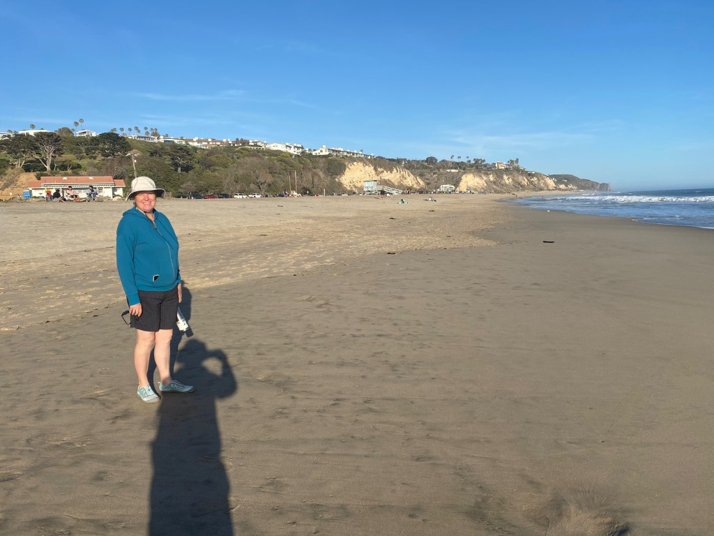
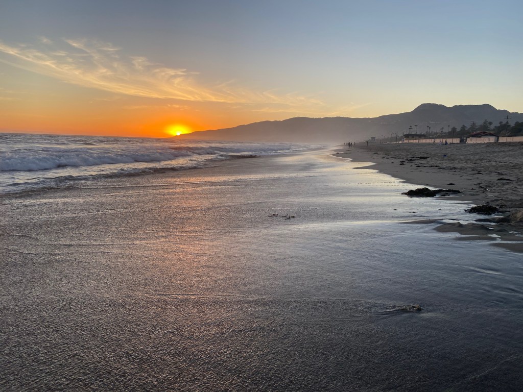
On Thursday Elizabeth and I walked for an hour on Zuma Beach in Malibu as the sun was setting.
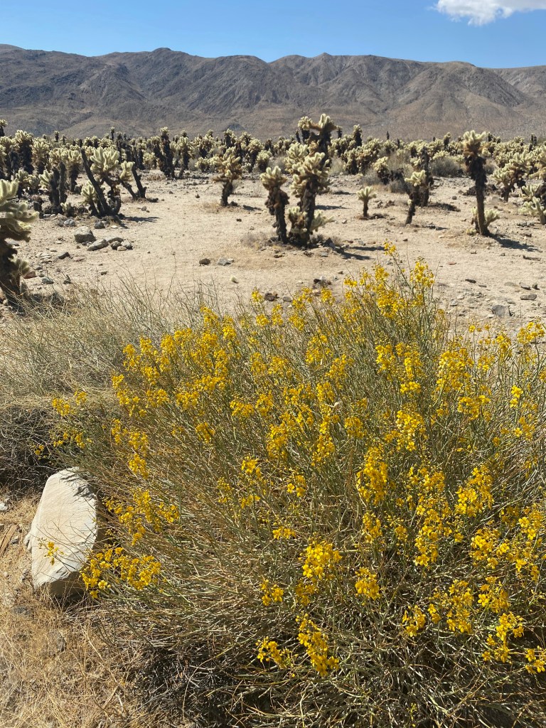
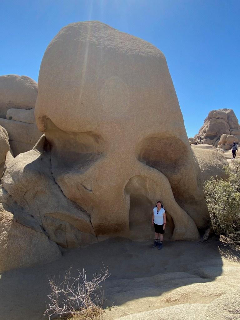
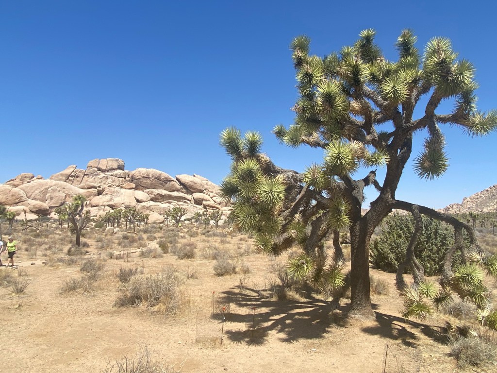
TWENTYNINE PALMS, CA – We drove through Joshua Tree N.P. yesterday, admiring the strangely formed plants that give the park its name and the granite boulders stacked in odd formations throughout the park.
A Joshua Tree near the Keys View lookout point.
The park is located just south of this city where we’ve parked our RV, and about 150 miles east of Los Angeles. The landscape is not spectacular in terms of mountain peaks and canyons, but it is strange and unique, with the twisted Joshua Trees dotting open areas surrounded by boulder fields. It’s worth a visit, although we found we could see it all easily in a day.
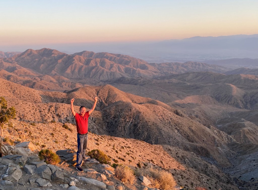
[Captions for the photos below: 1) Atop Keys View at sunset; the San Andreas Fault runs through the valley floor in the distance; 2) An oasis of palms at the Oasis Visitor Center; 3) The Cholla Cactus Garden in the park; 4) “The Skull” rock formation; 5) A frequent vista in the park; 6) A blooming hedgehog cactus along the Hidden Valley trail.]
Joshua Trees are not really trees but a species of yucca plant. They were named by early Morman settlers who thought their limbs resembled the outstretched arms of Moses’ successor leading Israel to victory as it conquered the promised land. Joshua 8:18 tells us:
Then the Lord said to Joshua, “Stretch out the javelin that is in your hand toward Ai, for I will give it into your hand.” And Joshua stretched out the javelin that was in his hand toward the city.
I was tempted to joke that the park was actually named in honor of the mega-selling, 1987 U2 album “The Joshua Tree.” Two of the songs from that album are among my favorites, “Still Haven’t Found What I’m Looking For” and “With or Without You.” They served as a fitting soundtrack as we left the park for home yesterday afternoon.
***
One of the many things I’ve learned during our time in this part of the country is that it’s too sweeping to refer, as I have in previous blogs, to “the desert southwest.” There are actually four desert systems: the Chihuahuan Desert, which we crossed in west Texas and southern New Mexico; the Sonoran Desert, home to the saguaro cactus; the Mohave Desert; and the Great Basin Desert that covers most of Nevada. Joshua Tree N.P. straddles the Mojave and Sonora deserts, adding to its diversity of plant and animal life.
We’ll be spending the next four weeks traveling through California, Lord willing. If anyone has suggestions about what we should see or people we can visit, please send the suggestions my way!
Dashboard:
Days on the road: 75;
Miles towing the RV: 3,756;
RV parks stayed at: 24;
National parks visited: 9.
The road ahead (Lord willing): Los Angeles and the West Coast
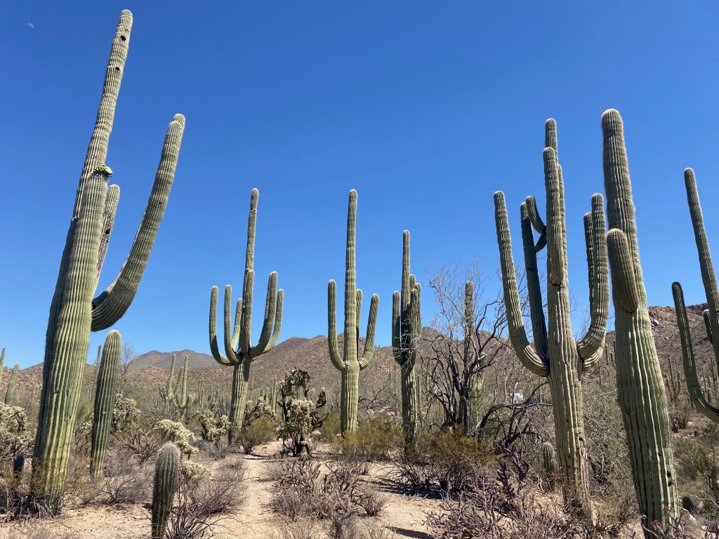
TUCSON, AZ – Who knew the desert Southwest could be so colorful? In our last full day in the Tucson area yesterday, we toured the Arizona-Sonora Desert Museum and the West section of the Saguaro National Park—getting up close to tall saguaro cacti and other blooming desert plants covering the rolling hills of the park.
On the Wild Dog Trail in Saguaro N.P.
The Desert Museum is located in the Tucson Mountain Park just south of the Visitor Center in the West section of the national park. Admission was not cheap–$23 per person–but it was a reasonable charge for the three hours we spent there viewing desert plants, wildlife and mineral riches mined in Arizona.
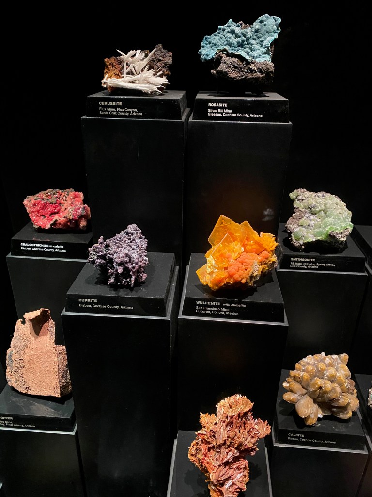
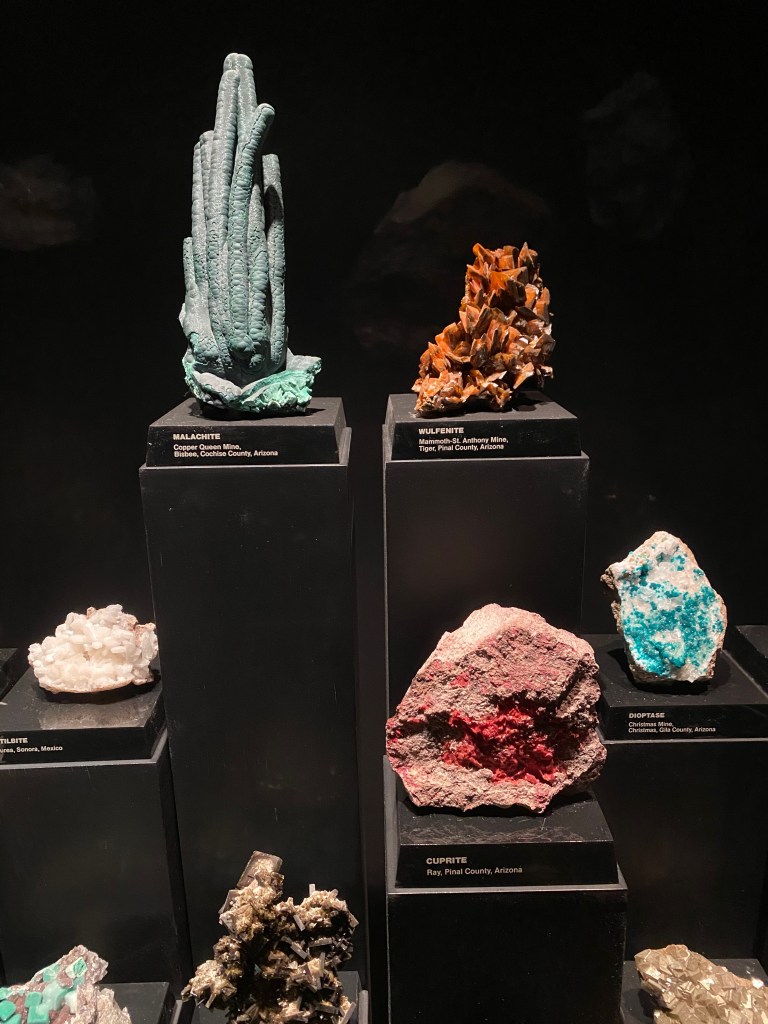
Among the highlights that you shouldn’t miss at the museum is the hummingbird aviary, where we were able to watch three of the little birds flit around us. I was especially impressed with the mineral collection, which I thought rivaled that of the Smithsonian’s Natural History Museum in Washington. The museum’s display was all the more impressive because almost all the colorful rocks were mined in Arizona or in nearby Mexico. (See photos below.)
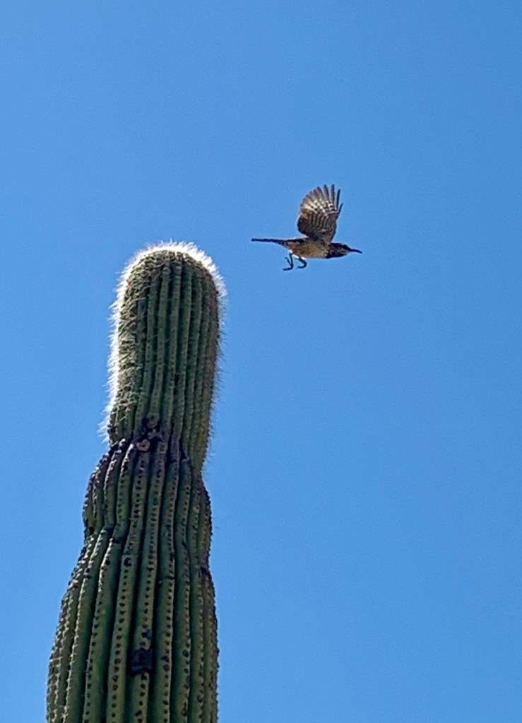
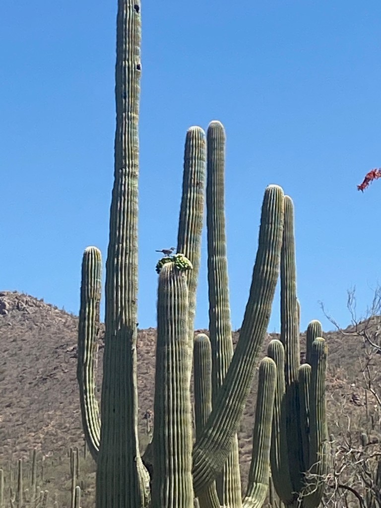
At the museum you can also see wildlife that would be much more rare to see in the park. We saw javalinas sleeping under a pedestrian bridge, a black bear, lots of rattlesnakes safely behind glass, a beaver, a large lizard sunning itself on a rock, and Mexican gray wolves. Elizabeth took the photo of the bird taking off from atop a saguaro cactus, and the coyote was on the road just outside the museum as we were leaving.
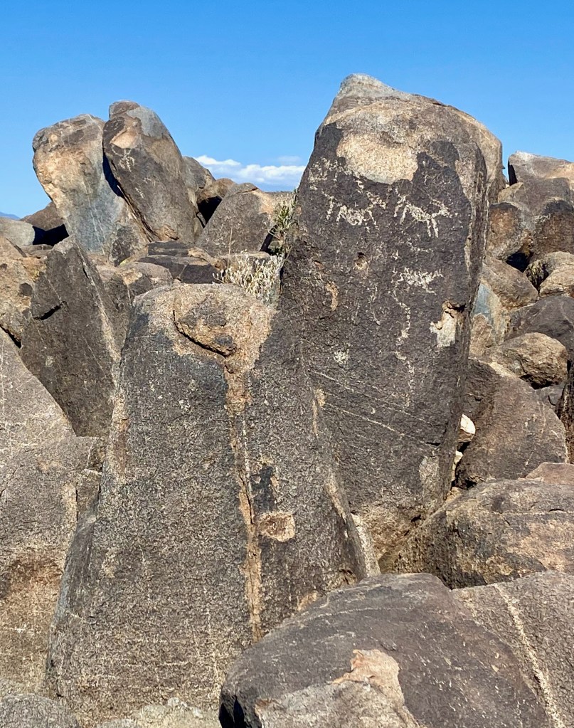
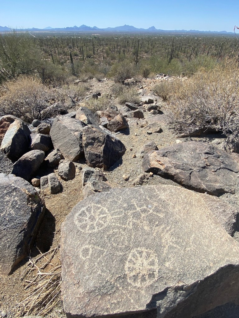
In Saguaro National Park, time limited us to the West section. We drove the 5-mile Bajada Loop through a forest of saguaro (pronounced suh-WAH-row) cacti. We hiked for a mile or so on the Cactus Wren and Wild Dog trails, surrounded by the towering stick figures known as the “sentinels of the desert.” At the visitor center we learned that the saguaro can grow to 40 feet or higher and only start sprouting arms at age 70. They are found in large numbers only in this part of the Sonora Desert. Toward the end of the loop we climbed a third of a mile to the top of Signal Hill to view petroglyphs created by the Hohokam Indians who lived in the area between 450 and 1450 AD.
This was an ideal time of year to visit this verdant desert park. Many of the plants are blooming with colorful flowers. The temperatures were in the 60s at the beginning of the day, peaking in the low 80s by afternoon, compared to highs near 100 that are normal during the summer months.
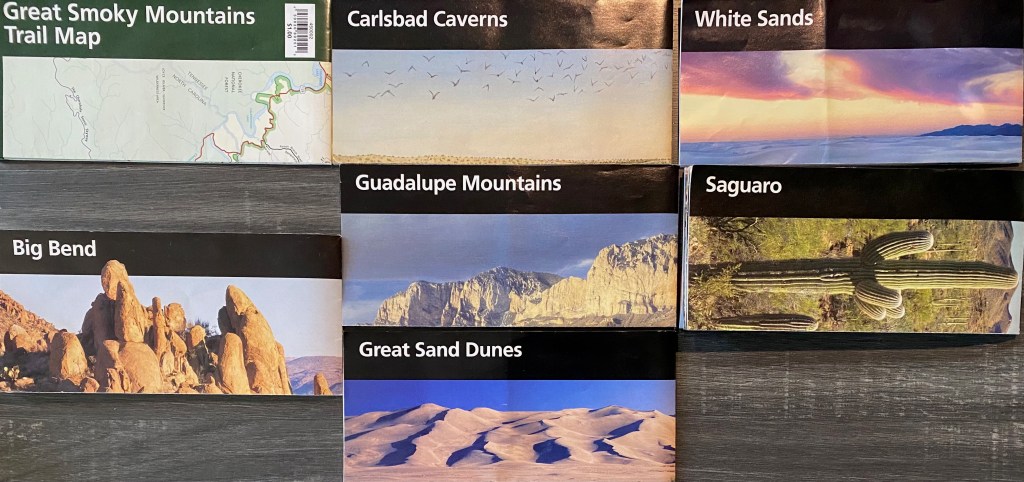
Saguaro marks the eighth national park we’ve enjoyed since we began our trip in early February. Seeing as many national parks as we can has been a kind of organizing principle of our itinerary. Lord willing, by the time we see Yellowstone N.P. in early July, we will have visited 20 national parks! (Here’s a montage of my trophies, minus the brochure for Hot Springs N.P. in Arkansas, which I must have absent-mindedly discarded along the way.)
***
On Sunday we worshiped at Covenant Orthodox Presbyterian Church in Tucson. We heard an excellent sermon from 1 Peter 2:11-17 from a guest preacher on how we should live as “resident aliens” in an unbelieving world. We also enjoyed renewing our connection with Pastor Christopher Chelpka, who was a pastoral intern at Grace OPC in Vienna more than a decade ago. If you are ever in the Tucson area and looking for a place to worship on Sunday, we highly recommend Covenant OPC.
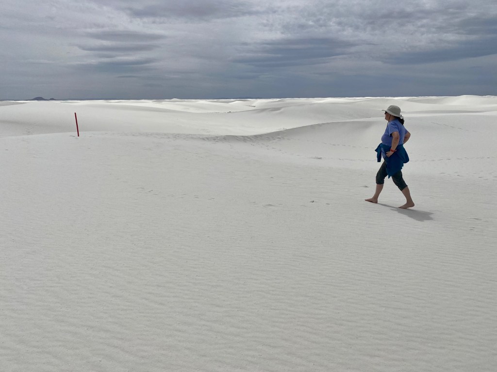
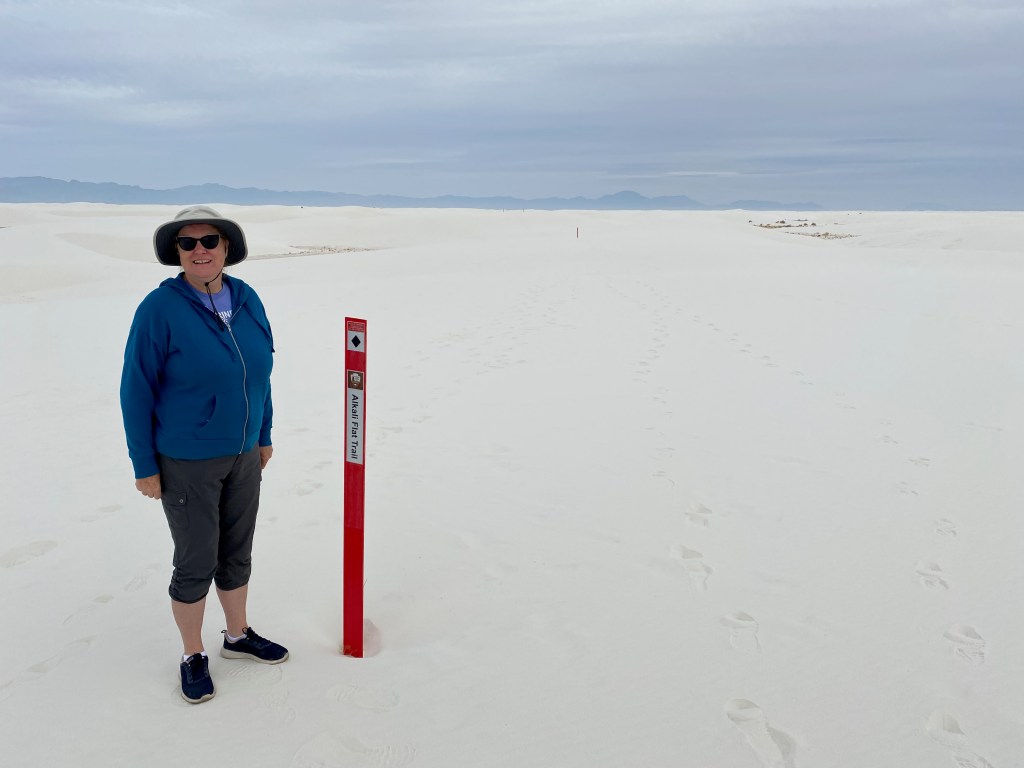
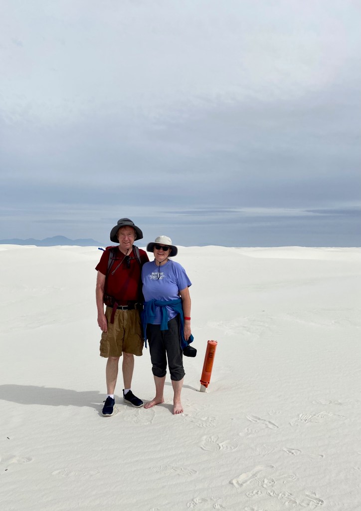
ALAMOGORDO, NM – Today we hiked through the gigantic 176,000-acre sandbox known as White Sands National Park. We walked for five miles over dunes mostly in our bare feet on the Alkali Flats Trail, the main excursion in the park.
It was an otherworldly experience to be surrounded by fine white sand in every direction, with the Sacramento Mountains in the distance. There is no normal trail out on the sands but instead red markers every few hundred feet to keep you on the path. The trail turns back where the sands reach the Alkali Flats, an ancient hard-packed seabed that the U.S. military uses as a missile range. (They actually close the park and nearby roads for a few hours each week when testing.)
“Elizabeth of the White Sands.” Movie rights under negotiation!
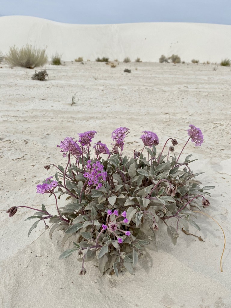
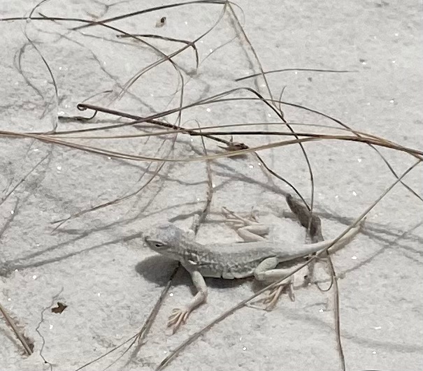
On our walk, we saw a beetle scurrying across the sand and a “bleached earless lizard,” which I understand is neither of those adjectives! We labored up the soft side of the sand dunes, but enjoyed sinking our feet in the cool sand on the downward slopes. Because the gypsum sand is white, it reflects the sunlight and stays cool. It’s also moist just beneath the surface because of the high water table, which tends to anchor the dunes and offer further delight for the feet of hikers.
If you hike this trail, our best advice is to go counter clockwise, which allows you to tackle the more challenging dunes when you are freshest. There is little elevation gain on the trail, but hikers still need to climb the dunes, which can reach 50 feet in height. We found that it’s easier to climb the windward side of a dune, where the sand is harder packed and the slope more gradual, which was more often the case on the return leg if you tackle the loop counter clockwise. Also take plenty of water—they recommend 2 liters per person—lather on the sunscreen, and wear a broad-brimmed sun hat. And if you can, visit in the non-summer months and start early in the day to avoid temperatures above 85 degrees F. It was about 70 degrees for us today with winds of 10 to 15 mph and we agreed we would not want it much warmer.
In August 2015 I read a news story about White Sands N.P. that has stuck with me to this day: A French couple touring the American west with their 9-year-old son had ventured out on the Alkali Flats Trail at mid-day with the temperature at 101 degrees and only two 20-ounce bottles of water. About a mile out, the mother felt ill and headed back toward the parking area, but she collapsed and died along the way. The father and son went about half a mile further before the father succumbed. Park staff found the son alive next to his dead father. The son was relatively well hydrated only because the parents had given him extra water, sacrificing themselves for his survival. Here’s a 2015 CNN story on the tragedy, and a New York Times follow up with further details. (The CNN story reports that heat-related deaths in national parks are rare; far more park visitors die from drownings, car crashes, and falls.)
***
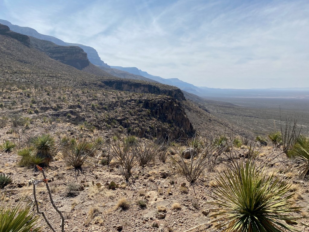
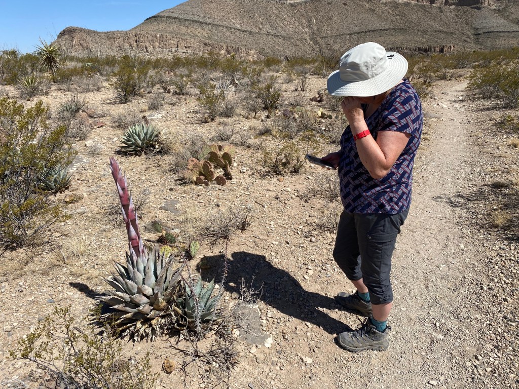
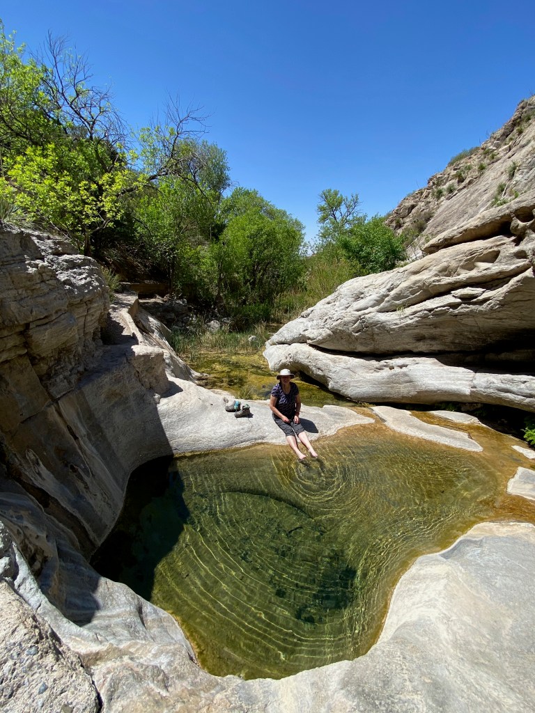
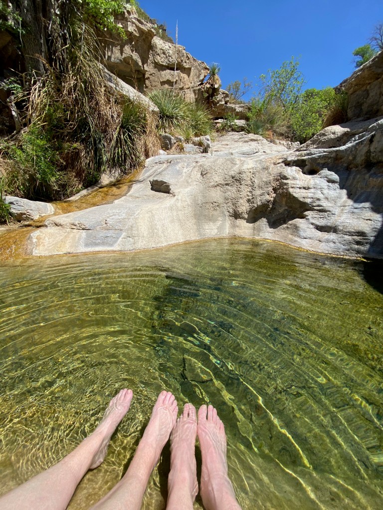
On Wednesday, we spent part of the day hiking in Oliver Lee State Park, located in Dog Canyon about 20 miles southeast of Alamogordo. The state park was recommended by a couple we met at another RV park and also by a National Geographic guidebook to state parks that we’ve brought along on our trip. The park was well worth the visit.
We started our excursion in the park with a 2.5-mile roundtrip hike up and along the side of Dog Canyon. Elizabeth continued her study of desert plants along the trail, and we both enjoyed the views back down the canyon to the valley floor. Our labors were rewarded back near the visitors center when we hiked a short way into the canyon to a spring-fed oasis. We enjoyed soaking our feet in a pool of clear, cool water, shaded by the surrounding cottonwood trees and other plants.
Dashboard:
Days on the road: 66;
Miles towing the RV: 3,044;
RV parks stayed at: 20;
National parks visited: 7.
The road ahead (Lord willing): Tucson, AZ, and Saguaro National Park
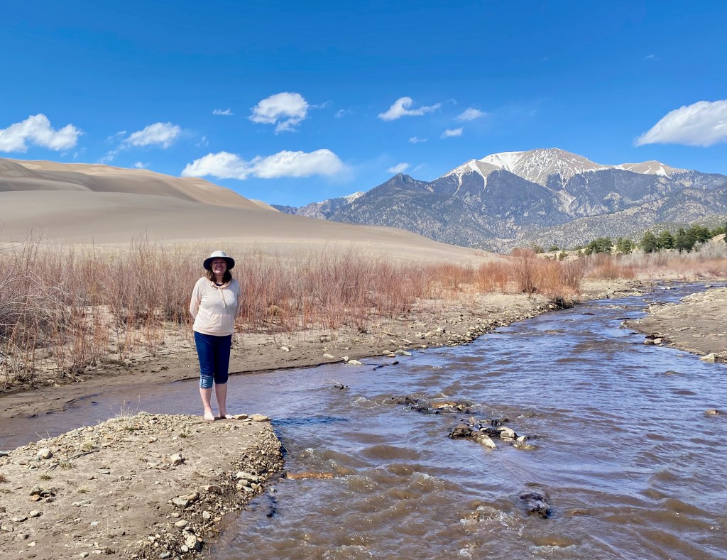
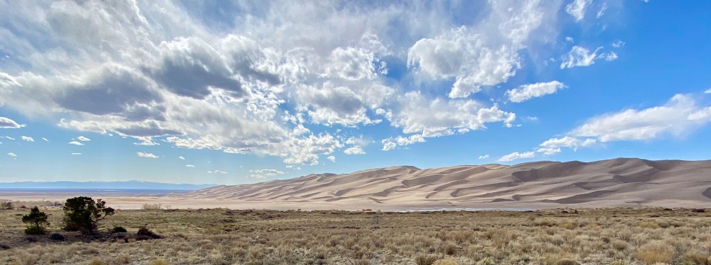
COLORADO SPRINGS, CO – On our last full day in Colorado Springs yesterday, we drove in the F-150 with Michael, Lizzy, and Max to the Great Sand Dunes N.P. about 170 miles south and west in the San Luis Valley.
The dunes have been a Griswold family favorite since our time in Colorado 30 years ago. In May 1994, I camped with Emily (6 at the time) and Michael (almost 3) to give Elizabeth a break while she looked after our newborn son Paul. We returned the next summer as a family before we moved away from Colorado to eventually settle in Northern Virginia.
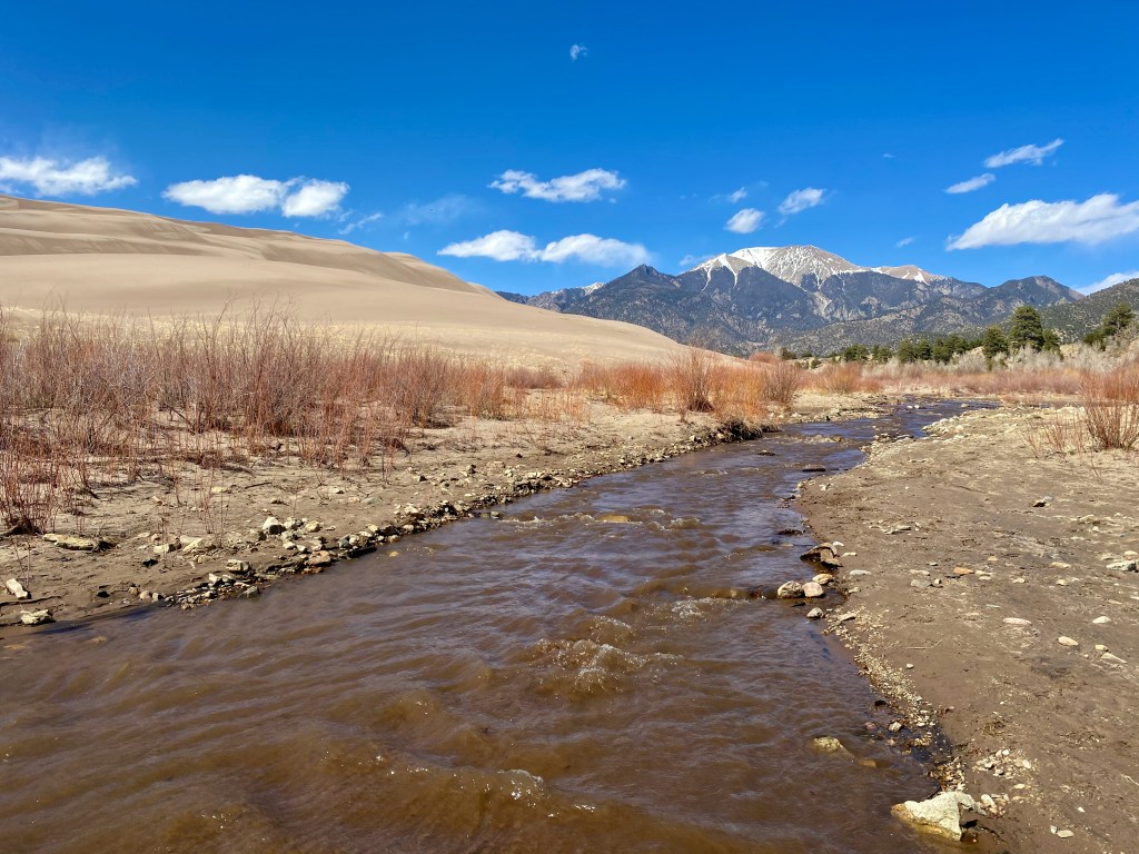
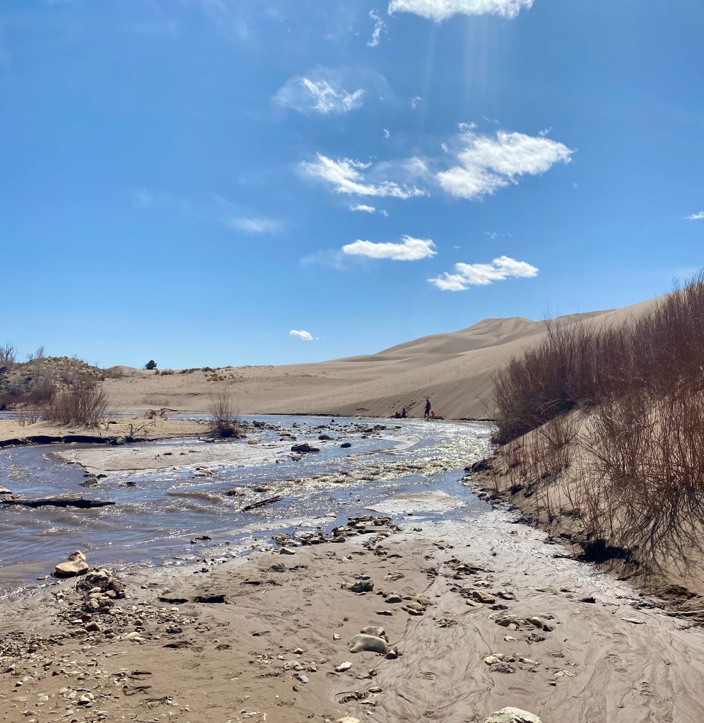
If you haven’t seen the dunes before, they’re an amazing sight: sand dunes piled as high as 700 feet above the valley floor, with Medano Creek running alongside the dunes in the spring and early summer, fed by snow melt from the Sangre de Cristo Mountains rising to the east and north.
On our visit yesterday, we were able to leave the crowds behind by driving a few miles up the 4-wheel-drive-only “Primitive Road” to the Sand Pit picnic area. We enjoyed a stretch of the creek and the dunes all to ourselves for about an hour before another family showed up.
If you visit the Great Sand Dunes, be sure to visit sometime between April and June when the creek is flowing. The water is refreshing, especially when the sand is starting to get hot. When the snow melt is at its peak later in the spring, gentle, regular “waves” will come down the creek.
While we were visiting Colorado, we left the RV at a Keystone dealer in Roswell for a few minor adjustments. After a 420-mile drive back to Roswell today, we plan to resume our RV adventure tomorrow with a drive to Alamogordo, NM.
Dashboard:
Days on the road: 63; Miles towing the RV: 2,924; RV parks stayed at: 19; National parks visited: 6.
Elizabeth and I spent almost the whole month of March traveling through Texas, arriving in Sulphur Springs on March 2 and departing the Guadalupe Mountains National Park for the last time on April 2, with stops in Waco, Austin, San Antonio, and Big Bend National Park along the way. It’s a great state in every way, from its geography to its economy and history.
One of the lasting impressions from our time in Texas is its immense size. From our entry into Texarkana to our exit into New Mexico a month later, we towed the RV 998 miles, plus a 180-mile side trip to the remote corner of Big Bend. That’s nearly 1,200 miles just to get through one state from east to west! (See the Google Map of our trek.)
Nothing captured the grandeur of Texas more for us than following US Highway 90 for 462 miles from San Antonio to Van Horn. The highway follows the path of a railway line that fueled the economy of the desert high plains a century ago. The road took us from the greenery of the San Antonio River to the scrub brush and dry river beds of the desert southwest, and to the mountain climates of Alpine, Fort Davis, and the Chisos and Guadalupe mountains.
Another impression from our time in Texas was the dynamism but also the disparity of its economy. Its big cities are thriving, with gleaming high rises, big universities, and suburban growth fueled by high tech and other 21st century industries. But we also saw boarded up store fronts and ramshackle housing in the smaller towns as we headed out onto the plains. This is not a criticism of Texas, since you can see the same in other parts of the country, but the contrast there seemed even starker.
Yet another lasting impression is the pride that Texans take in their history, including their time as an independent republic from 1836 to statehood in 1845. As Lyle Brunson pointed out to me, you see the Texas flag hanging in retail stores and lots of other places where you wouldn’t normally see a state flag elsewhere in the country. The electronic road signs in Austin said, “Slow down. You’re already in Texas!”
We spent a full afternoon with the Brunsons at the Alamo absorbing the history there. Texans are proud of what happened at the mission from February 23 to March 6, 1836, and with good reason. Fewer than 200 defenders held off a much larger Mexican army for those 13 days. All the men died, but not before by some counts killing an average of 10 Mexican soldiers each before the siege was broken. They bought enough time for Sam Houston to gather his troops and finally defeat Gen. Santa Anna at the decisive battle of San Jacinto on April 21, 1836.
For an accessible one-volume history of Texas, I highly recommend a book recommended to me by one of the staff at the Fabled Bookshop & Cafe in Waco: Lone Star: A History Of Texas And The Texans, by T. R. Fehrenbach (Da Capo Press, 2000). The author weaves a narrative that describes crucial events, the stock of immigrants who populated Texas, and how the vast landscape shaped the state’s culture and development.
I learned a lot about Stephen F. Austin, the statesman and visionary who brought the first 300 families—“The Old Three Hundred”– to settle in central Texas. As Fehrenbach writes, “In ten years, Austin located more than 1,500 American families, and these became the heart of Anglo-Texas. In a single decade, these people chopped more wood, cleared more land, broke more soil, raised more crops, had more children, and built more towns than the Spanish had in three hundred years.”
In the book and at the Alamo, I learned about William Travis, a military man and firebrand who died at the Alamo but not before becoming the Patrick Henry of Texas. At the end of a March 3, 1836, letter from the besieged mission appealing for reinforcements, Travis wrote, “God and Texas—Victory or Death!” Fehrenbach quotes another historian, Louis J. Wortham, who said of Travis’ letter, “It sealed forever the title of the Texans to the soil of Texas. The blood of Travis, of Bowie, of Bonham, of Crockett and the rest, consecrated the soil of Texas forever.”
During our month in Texas, I also came to appreciate the importance of geography in understanding the state. In crossing Texas, you cross a line that angles southwest roughly from Dallas, to just east of the Hill Country and down to Del Rio, a natural line that has shaped the state’s history and development. It’s where the greener, more well-watered forests and farmland of the east give way to the Balcones Escarpment and the high plans and mountains to the west.
West of the line, such industries as cotton farming were not possible, and thus the institution of slavery reached a natural barrier, checking its spread further west in the mid-19th century.
The high plains were also dominated by another barrier to development, the fearsome Comanche Indians. As Fehrenbach writes, “The Comanche hordes debouched on the Texas plains around the year 1725. They came like a thunderbolt; one historian compared them with the mounted hordes of Genghis Khan. Man, woman, and child, they were among the finest horsemen ever known.” In introducing the horse to the Indian tribes in Texas, the Spanish colonialists unwittingly created “the most fearsome light cavalry—the Plains Indian—the world had ever seen.”
Our month-long trek across Texas confirmed what Fehrenbach writes about the expansive and harsh West Texas landscape:
Over the whole land the sun burned, not the distant, friendly orb that filtered light through European forests, but a violent, brassy engine that browned the earth and made the hillsides shimmer with heat. …
If the American Manhattanite has almost forgotten he lives on soil, has shed his history, and is shaped more by social pressures than a sense of territory, the Texan can never, even in his cities, forget or be free of the brooding immensity of his land.
This book has been waiting patiently on my bookshelf for about 20 years, ever since a friend gave it to me as a present. The prospect of beholding new scenic wonders on this RV trip motivated me to finally read it, and I’m glad I did.
The key insight for me from Schreiner’s book is that God loves his creation, both the natural world and mankind, and for that reason he has not completely abandoned them to the forces of chaos and evil. This truth allows the Christian believer to more accurately see the hand of God in nature. As Schreiner writes,
Calvin insisted that the created world was not evil or alien to the believer. He stressed, therefore, not only the restraint of sin but also the remaining goodness and integrity of nature and society. Society was not, in Calvin’s view, the realm of darkness but was that arena in which the Christian pursued holiness. Calvin’s God did not reject his creation but continued to exercise providence over the “work of his hands” and to reveal his glory in this earthly “theater.” …
As the human soul is gradually restored to (and even surpasses) the original order characteristic of the image of God, so too the believer returns to that originally intended activity: namely, the contemplating of God’s revelation written in the book of nature and revealed in the visible splendor of the world.
Another useful insight from the book is that both nature and our own lives depend on the constant attention and benevolence of God. On p. 32, Schreiner quotes a vivid passage from Calvin on how precarious life on this earth really is and the multitude of ways a 16th century man could be struck down at any moment by an assortment of physical calamities. I’ve had more than one occasion on this RV trip to give thanks to God for watching over us during moments when things could have gone terribly wrong. We don’t appreciate that our lives are in God’s hands every moment of every day.